World Atlas: Malawi. On this page you can see the map, country flag and many detailed information about the people, history and economy of Malawi.

Here you can find online selected information about the geography, inhabitants, government, economy and history of Malawi. Included are selected statistics, an overview map and the detailed map of Malawi. But let's start with the flag of Malawi here:
Malawi - Overview:
What you should know about Malawi? Let's start with this: Established in 1891, the British protectorate of Nyasaland became the independent nation of Malawi in 1964. After three decades of one-party rule under President Hastings Kamuzu Banda, the country held multiparty presidential and parliamentary elections in 1994, under a provisional constitution that came into full effect the following year. President Bingu wa Mutharika, elected in 2004 after a failed attempt by the previous president to amend the constitution to permit another term, struggled to assert his authority against his predecessor and subsequently started his own party, the Democratic Progressive Party in 2005. Mutharika was reelected to a second term in 2009. He oversaw some economic improvement in his first term, but was accused of economic mismanagement and poor governance in his second term. He died abruptly in 2012 and was succeeded by vice president, Joyce Banda, who had earlier started her own party, the People's Party. Mutharika's brother, Peter Mutharika, defeated Banda in the 2014 election. Population growth, increasing pressure on agricultural lands, corruption, and the scourge of HIV/AIDS pose major problems for Malawi.
Geography of Malawi
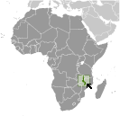 Where on the globe is Malawi? The location of this country is Southern Africa, east of Zambia, west and north of Mozambique. Total area of Malawi is 118,484 sq km, of which 94,080 sq km is land. So this is not a large country. How could we describe the terrain of the country? This way: narrow elongated plateau with rolling plains, rounded hills, some mountains. The lowest point of Malawi is junction of the Shire River and international boundary with Mozambique 37 m, the highest point Sapitwa (Mount Mlanje) 3,002 m. And the climate is sub-tropical; rainy season (November to May); dry season (May to November).
Inhabitants of Malawi
Let's take a look how many people live in Malawi. The number is: 19,196,246. So this is not very populous country. Who lives here? Chewa 35.1%, Lomwe 18.9%, Yao 13.1%, Ngoni 12%, Tumbuka 9.4%, Sena 3.5%, Tonga 1.8%, Nyanja 1%, Nkhonde 0.9%, other 1.8% (2015-16 est.). What are the languages in Malawi? English (official), Chichewa (common), Chinyanja, Chiyao, Chitumbuka, Chilomwe, Chinkhonde, Chingoni, Chisena, Chitonga, Chinyakyusa, Chilambya. And the religions: Protestant 27.2% (includes Church of Central Africa Presbyterian 17.7%, Seventh Day Adventist/Baptist 6.9%, Anglican 2.6%), Catholic 18.4%, other Christian 41%, Muslim 12.1%, other 0.3%, none 1% (2015-16 est.). How old are the people in average? 16.5 years. We have to add that this number is the median - so one half of the people is older than this, one half is younger. And what is their life expectancy (at birth)? This: 61.7 years. Where the people live in Malawi? Here: population density is highest south of Lake Nyasa. The major urban areas of Malawi are: Lilongwe (capital) 905,000; Blantyre-Limbe 808,000 (2015).
Government and Economy of Malawi
The capital of Malawi is Lilongwe and the government type presidential republic. Let's take a look at the administrative divisions - 28 districts; Balaka, Blantyre, Chikwawa, Chiradzulu, Chitipa, Dedza, Dowa, Karonga, Kasungu, Likoma, Lilongwe, Machinga, Mangochi, Mchinji, Mulanje, Mwanza, Mzimba, Neno, Ntcheu, Nkhata Bay, Nkhotakota, Nsanje, Ntchisi, Phalombe, Rumphi, Salima, Thyolo, Zomba. Regarding the economy of Malawi, important industrial products are tobacco, tea, sugar, sawmill products, cement, consumer goods. Important agricultural products are tobacco, sugarcane, tea, corn, potatoes, sweet potatoes, cassava (manioc, tapioca), sorghum, pulses, cotton, groundnuts, macadamia nuts, coffee; cattle, goats. The most important export commodities are tobacco 55%, dried legumes (8.8%), sugar (6.7%), tea (5.7%), cotton (2%), peanuts, coffee, soy (2015 est.) and the most important export partners are Zimbabwe 12.9%, Mozambique 11%, Belgium 8.2%, South Africa 7.2%, US 6%, China 4.6%, Germany 4.3%, UK 4.2% (2016). The most important import commodities are food, petroleum products, semi-manufactures, consumer goods, transportation equipment and the most important import partners are South Africa 20.2%, China 13.8%, India 10.8%, UAE 9.7%, Zambia 5.7% (2016). How rich is Malawi and how rich are people in this country? The most important number here is GDP per capita (PPP): $1,200 (2017 est.). This is a very low number. Let's add that this means Gross Domestic Product per person, which is recalculated with respect to the relative cost of local goods and services. And one more important number - population below poverty line: 50.7% (2010 est.).
