World Atlas: Turkmenistan. On this page you can see the map, country flag and many detailed information about the people, history and economy of Turkmenistan.

Here you can find online selected information about the geography, inhabitants, government, economy and history of Turkmenistan. Included are selected statistics, an overview map and the detailed map of Turkmenistan. But let's start with the flag of Turkmenistan here:
Turkmenistan - Overview:
What you should know about Turkmenistan? Let's start with this: Present-day Turkmenistan covers territory that has been at the crossroads of civilizations for centuries. The area was ruled in antiquity by various Persian empires, and was conquered by Alexander the Great, Muslim armies, the Mongols, Turkic warriors, and eventually the Russians. In medieval times, Merv (located in present-day Mary province) was one of the great cities of the Islamic world and an important stop on the Silk Road. Annexed by Russia in the late 1800s, Turkmenistan later figured prominently in the anti-Bolshevik movement in Central Asia. In 1924, Turkmenistan became a Soviet republic; it achieved independence upon the dissolution of the USSR in 1991. Extensive hydrocarbon/natural gas reserves, which have yet to be fully exploited, have begun to transform the country. The Government of Turkmenistan is moving to expand its extraction and delivery projects and has attempted to diversify its gas export routes beyond Russia's pipeline network. In 2010, new gas export pipelines that carry Turkmen gas to China and to northern Iran began operating, effectively ending the Russian monopoly on Turkmen gas exports. In 2016, Russia and Iran halted their purchase of gas from Turkmenistan making China the only buyer of Turkmen gas. President for Life Saparmurat Nyyazow died in December 2006, and Turkmenistan held its first multi-candidate presidential election in February 2007. Gurbanguly Berdimuhamedow, a deputy cabinet chairman under Nyyazow, emerged as the country's new president. He was reelected in 2012 and again in 2017 with over 97% of the vote in both instances, in elections widely regarded as undemocratic.
Geography of Turkmenistan
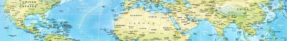
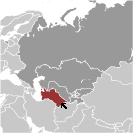 Where on the globe is Turkmenistan? The location of this country is Central Asia, bordering the Caspian Sea, between Iran and Kazakhstan. Total area of Turkmenistan is 488,100 sq km, of which 469,930 sq km is land. So this is quite a large country. How could we describe the terrain of the country? This way: flat-to-rolling sandy desert with dunes rising to mountains in the south; low mountains along border with Iran; borders Caspian Sea in west. The lowest point of Turkmenistan is Vpadina Akchanaya -81 m (Sarygamysh Koli is a lake in northern Turkmenistan with a water level that fluctuates above and below the elevation of Vpadina Akchanaya, the lake has dropped as low as -110 m), the highest point Gora Ayribaba 3,139 m. And the climate is subtropical desert.
Inhabitants of Turkmenistan
Let's take a look how many people live in Turkmenistan. The number is: 5,351,277 (July 2017 est.). So this is not very populous country. Who lives here? Turkmen 85%, Uzbek 5%, Russian 4%, other 6% (2003). What are the languages in Turkmenistan? Turkmen (official) 72%, Russian 12%, Uzbek 9%, other 7%. And the religions: Muslim 89%, Eastern Orthodox 9%, unknown 2%. How old are the people in average? 27.9 years. We have to add that this number is the median - so one half of the people is older than this, one half is younger. And what is their life expectancy (at birth)? This: 70.4 years. Where the people live in Turkmenistan? Here: the most densely populated areas are the southern, eastern, and northeastern oases; approximately 50% of the population lives in and around the capital of Ashgabat. The major urban areas of Turkmenistan are: Ashgabat (capital) 746,000 (2015).
Government and Economy of Turkmenistan
The capital of Turkmenistan is Ashgabat (Ashkhabad) and the government type presidential republic; authoritarian. Let's take a look at the administrative divisions - 5 provinces (welayatlar, singular - welayat) and 1 independent city: Ahal Welayaty (Anew), Ashgabat, Balkan Welayaty (Balkanabat), Dasoguz Welayaty, Lebap Welayaty (Turkmenabat), Mary Welayaty. Regarding the economy of Turkmenistan, important industrial products are natural gas, oil, petroleum products, textiles, food processing. Important agricultural products are cotton, grain, melons; livestock. The most important export commodities are gas, crude oil, petrochemicals, textiles, cotton fibe and the most important export partners are China 70%, Turkey 5.3%, Italy 5.3%, Afghanistan 4.5%, Russia 4.1% (2016). The most important import commodities are machinery and equipment, chemicals, foodstuffs and the most important import partners are Turkey 26.4%, Russia 10.5%, Japan 8.6%, Germany 8.2%, South Korea 7.8%, China 7.2%, Italy 5.2% (2016). How rich is Turkmenistan and how rich are people in this country? The most important number here is GDP per capita (PPP): $18,700 (2017 est.). This is quite good. Let's add that this means Gross Domestic Product per person, which is recalculated with respect to the relative cost of local goods and services. And one more important number - population below poverty line: 0.2% (2012 est.).
