World Atlas: Bhutan. On this page you can see the map, country flag and many detailed information about the people, history and economy of Bhutan.
Here you can find online selected information about the geography, inhabitants, government, economy and history of Bhutan. Included are selected statistics, an overview map and the detailed map of Bhutan. But let's start with the flag of Bhutan here:
Bhutan - Overview:
What you should know about Bhutan? Let's start with this: Following Britain’s victory in the 1865 Duar War, Britain and Bhutan signed the Treaty of Sinchulu, under which Bhutan would receive an annual subsidy in exchange for ceding land to British India. Ugyen Wangchuck - who had served as the de facto ruler of an increasingly unified Bhutan and had improved relations with the British toward the end of the 19th century - was named king in 1907. Three years later, a treaty was signed whereby the British agreed not to interfere in Bhutanese internal affairs, and Bhutan allowed Britain to direct its foreign affairs. Bhutan negotiated a similar arrangement with independent India after 1947. Two years later, a formal Indo-Bhutanese accord returned to Bhutan a small piece of the territory annexed by the British, formalized the annual subsidies the country received, and defined India's responsibilities in defense and foreign relations. Under a succession of modernizing monarchs beginning in the 1950s, Bhutan joined the UN in 1971 and slowly continued its engagement beyond its borders. In March 2005, King Jigme Singye Wangchuck unveiled the government's draft constitution - which introduced major democratic reforms - and held a national referendum for its approval. In December 2006, the King abdicated the throne in favor of his son, Jigme Khesar Namgyel Wangchuck. In early 2007, India and Bhutan renegotiated their treaty, eliminating the clause that stated that Bhutan would be "guided by" India in conducting its foreign policy, although Thimphu continues to coordinate closely with New Delhi. Elections for seating the country's first parliament were completed in March 2008; the king ratified the country's first constitution in July 2008. Bhutan experienced a peaceful turnover of power following parliamentary elections in 2013, which resulted in the defeat of the incumbent party. The disposition of some 8,500 refugees of the more than 100,000 who fled or were forced out of Bhutan in the 1990s - and who are housed in two UN refugee camps in Nepal - remains unresolved.
Geography of Bhutan
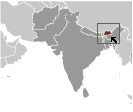 Where on the globe is Bhutan? The location of this country is Southern Asia, between China and India. Total area of Bhutan is 38,394 sq km, of which 38,394 sq km is land. So this is not a large country. How could we describe the terrain of the country? This way: mostly mountainous with some fertile valleys and savanna. The lowest point of Bhutan is Drangeme Chhu 97 m, the highest point Gangkar Puensum 7,570 m. And the climate is varies; tropical in southern plains; cool winters and hot summers in central valleys; severe winters and cool summers in Himalayas.
Inhabitants of Bhutan
Let's take a look how many people live in Bhutan. The number is: 758,288 (July 2017 est.). So not so many people live here. Who lives here? Ngalop (also known as Bhote) 50%, ethnic Nepalese 35% (includes Lhotsampas - one of several Nepalese ethnic groups), indigenous or migrant tribes 15%. What are the languages in Bhutan? Sharchhopka 28%, Dzongkha (official) 24%, Lhotshamkha 22%, other 26% (includes foreign languages) (2005 est.). And the religions: Lamaistic Buddhist 75.3%, Indian- and Nepalese-influenced Hinduism 22.1%, other 2.6% (2005 est.). How old are the people in average? 27.6 years. We have to add that this number is the median - so one half of the people is older than this, one half is younger. And what is their life expectancy (at birth)? This: 70.6 years. Where the people live in Bhutan? Here: unknown. The major urban areas of Bhutan are: Thimphu (capital) 152,000 (2014).
Government and Economy of Bhutan
The capital of Bhutan is Thimphu and the government type constitutional monarchy. Let's take a look at the administrative divisions - 20 districts (dzongkhag, singular and plural); Bumthang, Chhukha, Chirang, Daga, Gasa, Geylegphug, Ha, Lhuntshi, Mongar, Paro, Pemagatsel, Punakha, Samchi, Samdrup Jongkhar, Shemgang, Tashigang, Tashi Yangtse, Thimphu, Tongsa, Wangdi Phodrang. Regarding the economy of Bhutan, important industrial products are cement, wood products, processed fruits, alcoholic beverages, calcium carbide, tourism. Important agricultural products are rice, corn, root crops, citrus; dairy products, eggs. The most important export commodities are electricity (to India), ferrosilicon, cement, cardamom, calcium carbide, steel rods/bars, dolomite, gypsum and the most important export partners are India 95.7% (2016). The most important import commodities are fuel and lubricants, airplanes, machinery and parts, rice, motor vehicles and the most important import partners are India 91.1% (2016). How rich is Bhutan and how rich are people in this country? The most important number here is GDP per capita (PPP): $8,700 (2017 est.). This is quite a low number. Let's add that this means Gross Domestic Product per person, which is recalculated with respect to the relative cost of local goods and services. And one more important number - population below poverty line: 13.3% (2012 est.).
