World Atlas: Congo, Democratic Republic. On this page you can see the map, country flag and many detailed information about the people, history and economy of Congo, Democratic Republic.

Here you can find online selected information about the geography, inhabitants, government, economy and history of Congo, Democratic Republic. Included are selected statistics, an overview map and the detailed map of Congo, Democratic Republic. But let's start with the flag of Congo, Democratic Republic here:
Congo, Democratic Republic - Overview:
What you should know about Congo, Democratic Republic? Let's start with this: Established as an official Belgian colony in 1908, the then-Republic of the Congo gained its independence in 1960, but its early years were marred by political and social instability. Col. Joseph Mobutu seized power and declared himself president in a November 1965 coup. He subsequently changed his name - to Mobutu Sese Seko - as well as that of the country - to Zaire. Mobutu retained his position for 32 years through several sham elections, as well as through brutal force. Ethnic strife and civil war, touched off by a massive inflow of refugees in 1994 from fighting in Rwanda and Burundi, led in May 1997 to the toppling of the Mobutu regime by a rebellion backed by Rwanda and Uganda and fronted by Laurent Kabila. Kabila renamed the country the Democratic Republic of the Congo (DRC), but in August 1998 his regime was itself challenged by a second insurrection again backed by Rwanda and Uganda. Troops from Angola, Chad, Namibia, Sudan, and Zimbabwe intervened to support Kabila's regime. In January 2001, Kabila was assassinated and his son, Joseph Kabila, was named head of state. In October 2002, the new president was successful in negotiating the withdrawal of Rwandan forces occupying the eastern DRC; two months later, the Pretoria Accord was signed by all remaining warring parties to end the fighting and establish a government of national unity. A transitional government was set up in July 2003; it held a successful constitutional referendum in December 2005 and elections for the presidency, National Assembly, and provincial legislatures took place in 2006. In 2009, following a resurgence of conflict in the eastern DRC, the government signed a peace agreement with the National Congress for the Defense of the People (CNDP), a primarily Tutsi rebel group. An attempt to integrate CNDP members into the Congolese military failed, prompting their defection in 2012 and the formation of the M23 armed group - named after the 23 March 2009 peace agreements. Renewed conflict led to large population displacements and significant human rights abuses before the M23 was pushed out of DRC to Uganda and Rwanda in late 2013 by a joint DRC and UN offensive. In addition, the DRC continues to experience violence committed by other armed groups including the Democratic Forces for the Liberation of Rwanda, the Allied Democratic Forces, and assorted Mai Mai militias. In the most recent national elections, held in November 2011, disputed results allowed Joseph Kabila to be reelected to the presidency. The DRC Constitution bars President Kabila from running for a third term, but the DRC Government has delayed national elections, originally slated for November 2016, to December 2018. The failure to hold elections as scheduled has fueled sporadic street protests by Kabila’s opponents.
Geography of Congo, Democratic Republic
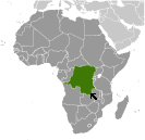 Where on the globe is Congo, Democratic Republic? The location of this country is Central Africa, northeast of Angola. Total area of Congo, Democratic Republic is 2,344,858 sq km, of which 2,267,048 sq km is land. So this is very large country. How could we describe the terrain of the country? This way: vast central basin is a low-lying plateau; mountains in east. The lowest point of Congo, Democratic Republic is Atlantic Ocean 0 m, the highest point Pic Marguerite on Mont Ngaliema (Mount Stanley) 5,110 m. And the climate is tropical; hot and humid in equatorial river basin; cooler and drier in southern highlands; cooler and wetter in eastern highlands; north of Equator - wet season (April to October), dry season (December to February); south of Equator - wet season (November to March), dry season (April to October).
Inhabitants of Congo, Democratic Republic
Let's take a look how many people live in Congo, Democratic Republic. The number is: 83,301,151. So this country is among the most populous in the World. Who lives here? over 200 African ethnic groups of which the majority are Bantu; the four largest tribes - Mongo, Luba, Kongo (all Bantu), and the Mangbetu-Azande (Hamitic) make up about 45% of the population. What are the languages in Congo, Democratic Republic? French (official), Lingala (a lingua franca trade language), Kingwana (a dialect of Kiswahili or Swahili), Kikongo, Tshiluba. And the religions: Roman Catholic 50%, Protestant 20%, Kimbanguist 10%, Muslim 10%, other (includes syncretic sects and indigenous beliefs) 10%. How old are the people in average? 18.6 years. We have to add that this number is the median - so one half of the people is older than this, one half is younger. And what is their life expectancy (at birth)? This: 57.7 years. Where the people live in Congo, Democratic Republic? Here: urban clusters are spread throughout the country, particularly in the northeast along the boarder with Uganda, Rwanda, and Burundi; the largest city is the capital, Kinshasha, located in the west along the Congo River; the south is least densely populated. The major urban areas of Congo, Democratic Republic are: Kinshasa (capital) 11.587 million; Lubumbashi 2.015 million; Mbuji-Mayi 2.007 million; Kananga 1.169 million; Kisangani 1.04 million; Bukavu 832,000 (2015).
Government and Economy of Congo, Democratic Republic
The capital of Congo, Democratic Republic is Kinshasa and the government type semi-presidential republic. Let's take a look at the administrative divisions - 26 provinces (provinces, singular - province); Bas-Uele (Lower Uele), Equateur, Haut-Katanga (Upper Katanga), Haut-Lomami (Upper Lomami), Haut-Uele (Upper Uele), Ituri, Kasai, Kasai-Central, Kasai-Oriental (East Kasai), Kinshasa, Kongo Central, Kwango, Kwilu, Lomami, Lualaba, Mai-Ndombe, Maniema, Mongala, Nord-Kivu (North Kivu), Nord-Ubangi (North Ubangi), Sankuru, Sud-Kivu (South Kivu), Sud-Ubangi (South Ubangi), Tanganyika, Tshopo, Tshuapa. Regarding the economy of Congo, Democratic Republic, important industrial products are mining (copper, cobalt, gold, diamonds, coltan, zinc, tin, tungsten), mineral processing, consumer products (textiles, plastics, footwear, cigarettes), metal products, processed foods and beverages, timber, cement, commercial ship repai. Important agricultural products are coffee, sugar, palm oil, rubber, tea, cotton, cocoa, quinine, cassava (manioc, tapioca), bananas, plantains, peanuts, root crops, corn, fruits; wood products. The most important export commodities are diamonds, copper, gold, cobalt, wood products, crude oil, coffee and the most important export partners are China 35.3%, Zambia 15.8%, South Korea 8.7%, Saudi Arabia 8%, Belgium 5.2% (2016). The most important import commodities are foodstuffs, mining and other machinery, transport equipment, fuels and the most important import partners are China 20.2%, South Africa 15.7%, Zambia 8.6%, Belgium 7.6%, Tanzania 5.8%, France 5.2%, India 4.6%, Kenya 4.2% (2016). How rich is Congo, Democratic Republic and how rich are people in this country? The most important number here is GDP per capita (PPP): $800 (2017 est.). This is a very low number. Let's add that this means Gross Domestic Product per person, which is recalculated with respect to the relative cost of local goods and services. And one more important number - population below poverty line: 63% (2012 est.).
