World Atlas: Cote d'Ivoire. On this page you can see the map, country flag and many detailed information about the people, history and economy of Cote d'Ivoire.

Here you can find online selected information about the geography, inhabitants, government, economy and history of Cote d'Ivoire. Included are selected statistics, an overview map and the detailed map of Cote d'Ivoire. But let's start with the flag of Cote d'Ivoire here:
Cote d'Ivoire - Overview:
What you should know about Cote d'Ivoire? Let's start with this: Close ties to France following independence in 1960, the development of cocoa production for export, and foreign investment all made Cote d'Ivoire one of the most prosperous of the West African states but did not protect it from political turmoil. In December 1999, a military coup - the first ever in Cote d'Ivoire's history - overthrew the government. Junta leader Robert GUEI blatantly rigged elections held in late 2000 and declared himself the winner. Popular protest forced him to step aside and an election brought Laurent Gbagbo into power. Ivoirian dissidents and disaffected members of the military launched a failed coup attempt in September 2002 that developed into a rebellion and then a civil war. In 2003, a cease-fire resulted in the country being divided with the rebels holding the north, the government the south, and peacekeeping forces a buffer zone between the two. In March 2007, President Gbagbo and former New Forces rebel leader Guillaume SORO signed an agreement in which SORO joined Gbagbo's government as prime minister and the two agreed to reunite the country by dismantling the buffer zone, integrating rebel forces into the national armed forces, and holding elections. Difficulties in preparing electoral registers delayed balloting until 2010. In November 2010, Alassane Dramane Ouattara won the presidential election over Gbagbo, but Gbagbo refused to hand over power, resulting in a five-month resumption of violent conflict. In April 2011, after widespread fighting, Gbagbo was formally forced from office by armed Ouattara supporters with the help of UN and French forces. The UN peacekeeping mission departed in June 2017. Ouattara is focused on rebuilding the country's economy and infrastructure while rebuilding the security forces. Gbagbo is in The Hague on trial for crimes against humanity.
Geography of Cote d'Ivoire
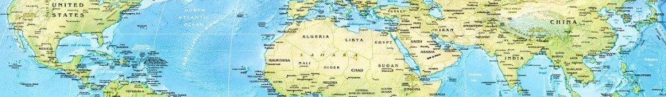
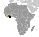 Where on the globe is Cote d'Ivoire? The location of this country is Western Africa, bordering the North Atlantic Ocean, between Ghana and Liberia. Total area of Cote d'Ivoire is 322,463 sq km, of which 318,003 sq km is land. So this is quite a large country. How could we describe the terrain of the country? This way: mostly flat to undulating plains; mountains in northwest. The lowest point of Cote d'Ivoire is Gulf of Guinea 0 m, the highest point Monts Nimba 1,752 m. And the climate is tropical along coast, semiarid in far north; three seasons - warm and dry (November to March), hot and dry (March to May), hot and wet (June to October).
Inhabitants of Cote d'Ivoire
Let's take a look how many people live in Cote d'Ivoire. The number is: 24,184,810. So quite a lot people live here. Who lives here? Akan 28.8%, Voltaique or Gur 16.1%, Northern Mande 14.5%, Kru 8.5%, Southern Mande 6.9%, unspecified 0.9%, non-Ivoirian 42.3% (2014 est.). What are the languages in Cote d'Ivoire? French (official), 60 native dialects of which Dioula is the most widely spoken. And the religions: Muslim 42.9%, Catholic 17.2%, Evangelical 11.8%, Methodist 1.7%, other Christian 3.2%, animist 3.6%, other religion 0.5%, none 19.1%. How old are the people in average? 20.9 years. We have to add that this number is the median - so one half of the people is older than this, one half is younger. And what is their life expectancy (at birth)? This: 59 years. Where the people live in Cote d'Ivoire? Here: the population is primarily located in the forested south, with the highest concentration of people residing in and around the cities on the Atlantic coast; most of the northern savanna remains sparsely populated with higher concentrations located along transportation corridors. The major urban areas of Cote d'Ivoire are: Yamoussoukro (capital) 259,000 (2014); Abidjan (seat of government) 4.86 million; Bouake 762,000 (2015).
Government and Economy of Cote d'Ivoire
The capital of Cote d'Ivoire is Yamoussoukro (legislative capital), Abidjan (administrative capital); note - although Yamoussoukro has been the official capital since 1983, Abidjan remains the administrative capital as well as the officially designated commercial capital; the US, like other countries, maintains its Embassy in Abidjan and the government type presidential republic. Let's take a look at the administrative divisions - 12 districts and 2 autonomous districts; Abidjan, Bas-Sassandra, Comoe, Denguele, Goh-Djiboua, Lacs, Lagunes, Montagnes, Sassandra-Marahoue, Savanes, Vallee du Bandama, Woroba, Yamoussoukro, Zanzan. Regarding the economy of Cote d'Ivoire, important industrial products are foodstuffs, beverages; wood products, oil refining, gold mining, truck and bus assembly, textiles, fertilizer, building materials, electricity. Important agricultural products are coffee, cocoa beans, bananas, palm kernels, corn, rice, cassava (manioc, tapioca), sweet potatoes, sugar, cotton, rubber; timbe. The most important export commodities are cocoa, coffee, timber, petroleum, cotton, bananas, pineapples, palm oil, fish and the most important export partners are Netherlands 11.3%, US 7.4%, France 6.8%, Belgium 6.1%, Germany 5.2%, India 5.1%, Burkina Faso 4.6%, Mali 4.5%, Switzerland 4.1% (2016). The most important import commodities are fuel, capital equipment, foodstuffs and the most important import partners are France 13.5%, Nigeria 13.3%, China 11.8%, US 4.2% (2016). How rich is Cote d'Ivoire and how rich are people in this country? The most important number here is GDP per capita (PPP): $3,900 (2017 est.). This is a very low number. Let's add that this means Gross Domestic Product per person, which is recalculated with respect to the relative cost of local goods and services. And one more important number - population below poverty line: 46.3% (2015 est.).
