World Atlas: Mauritius. On this page you can see the map, country flag and many detailed information about the people, history and economy of Mauritius.
Here you can find online selected information about the geography, inhabitants, government, economy and history of Mauritius. Included are selected statistics, an overview map and the detailed map of Mauritius. But let's start with the flag of Mauritius here:
Mauritius - Overview:
What you should know about Mauritius? Let's start with this: Although known to Arab and Malay sailors as early as the 10th century, Mauritius was first explored by the Portuguese in the 16th century and subsequently settled by the Dutch - who named it in honor of Prince Maurits van Nassau - in the 17th century. The French assumed control in 1715, developing the island into an important naval base overseeing Indian Ocean trade, and establishing a plantation economy of sugar cane. The British captured the island in 1810, during the Napoleonic Wars. Mauritius remained a strategically important British naval base, and later an air station, playing an important role during World War II for anti-submarine and convoy operations, as well as the collection of signals intelligence. Independence from the UK was attained in 1968. A stable democracy with regular free elections and a positive human rights record, the country has attracted considerable foreign investment and has one of Africa's highest per capita incomes.
Geography of Mauritius
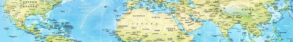
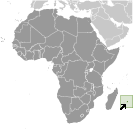 Where on the globe is Mauritius? The location of this country is Southern Africa, island in the Indian Ocean, about 800 km (500 mi) east of Madagasca. Total area of Mauritius is 2,040 sq km, of which 2,030 sq km is land. So this is quite a small country. How could we describe the terrain of the country? This way: small coastal plain rising to discontinuous mountains encircling central plateau. The lowest point of Mauritius is Indian Ocean 0 m, the highest point Mont Piton 828 m. And the climate is tropical, modified by southeast trade winds; warm, dry winter (May to November); hot, wet, humid summer (November to May).
Inhabitants of Mauritius
Let's take a look how many people live in Mauritius. The number is: 1,356,388 (July 2017 est.). So not so many people live here. Who lives here? Indo-Mauritian (compose approximately two thirds of the total population), Creole, Sino-Mauritian, Franco-Mauritian. What are the languages in Mauritius? Creole 86.5%, Bhojpuri 5.3%, French 4.1%, two languages 1.4%, other 2.6% (includes English, the official language of the National Assembly, which is spoken by less than 1% of the population), unspecified 0.1% (2011 est.). And the religions: Hindu 48.5%, Roman Catholic 26.3%, Muslim 17.3%, other Christian 6.4%, other 0.6%, none 0.7%, unspecified 0.1% (2011 est.). How old are the people in average? 35.3 years. We have to add that this number is the median - so one half of the people is older than this, one half is younger. And what is their life expectancy (at birth)? This: 75.8 years. Where the people live in Mauritius? Here: population density is one of the highest in the world; urban cluster are found throught the main island, with a greater density in and around Port Luis; population on Rodrigues Island is spread across the island with a slightly denser cluster on the north coast. The major urban areas of Mauritius are: PORT Louis (capital) 135,000 (2014).
Government and Economy of Mauritius
The capital of Mauritius is Port Louis and the government type parliamentary republic. Let's take a look at the administrative divisions - 9 districts and 3 dependencies; Agalega Islands, Black River, Cargados Carajos Shoals, Flacq, Grand Port, Moka, Pamplemousses, Plaines Wilhems, Port Louis, Riviere du Rempart, Rodrigues, Savanne. Regarding the economy of Mauritius, important industrial products are food processing (largely sugar milling), textiles, clothing, mining, chemicals, metal products, transport equipment, nonelectrical machinery, tourism. Important agricultural products are sugarcane, tea, corn, potatoes, bananas, pulses; cattle, goats; fish. The most important export commodities are clothing and textiles, sugar, cut flowers, molasses, fish, primates (for research) and the most important export partners are France 14.8%, UK 12%, US 11.4%, South Africa 8.2%, Madagascar 7.3%, Italy 6.8%, Spain 4.5% (2016). The most important import commodities are manufactured goods, capital equipment, foodstuffs, petroleum products, chemicals and the most important import partners are China 17.7%, India 16.5%, France 7.8%, South Africa 7.5% (2016). How rich is Mauritius and how rich are people in this country? The most important number here is GDP per capita (PPP): $21,600 (2017 est.). This means the living standards are good here. Let's add that this means Gross Domestic Product per person, which is recalculated with respect to the relative cost of local goods and services. And one more important number - population below poverty line: 8% (2006 est.).
