World Atlas: Benin. On this page you can see the map, country flag and many detailed information about the people, history and economy of Benin.

Here you can find online selected information about the geography, inhabitants, government, economy and history of Benin. Included are selected statistics, an overview map and the detailed map of Benin. But let's start with the flag of Benin here:
Benin - Overview:
What you should know about Benin? Let's start with this: Present day Benin was the site of Dahomey, a West African kingdom that rose to prominence in about 1600 and over the next two and a half centuries became a regional power, largely based on its slave trade. Coastal areas of Dahomey began to be controlled by the French in the second half of the 19th century; the entire kingdom was conquered by 1894. French Dahomey achieved independence in 1960; it changed its name to the Republic of Benin in 1975. A succession of military governments ended in 1972 with the rise to power of Mathieu Kerekou and the establishment of a government based on Marxist-Leninist principles. A move to representative government began in 1989. Two years later, free elections ushered in former Prime Minister Nicephore Soglo as president, marking the first successful transfer of power in Africa from a dictatorship to a democracy. Kerekou was returned to power by elections held in 1996 and 2001, though some irregularities were alleged. Kerekou stepped down at the end of his second term in 2006 and was succeeded by Thomas YAYI Boni, a political outsider and independent, who won a second five-year term in March 2011. Patrice Talon, a wealthy businessman, took office in 2016 after campaigning to restore public confidence in the government.
Geography of Benin
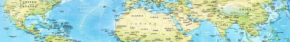
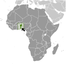 Where on the globe is Benin? The location of this country is Western Africa, bordering the Bight of Benin, between Nigeria and Togo. Total area of Benin is 112,622 sq km, of which 110,622 sq km is land. So this is not a large country. How could we describe the terrain of the country? This way: mostly flat to undulating plain; some hills and low mountains. The lowest point of Benin is Atlantic Ocean 0 m, the highest point Mont Sokbaro 658 m. And the climate is tropical; hot, humid in south; semiarid in north.
Inhabitants of Benin
Let's take a look how many people live in Benin. The number is: 11,038,805. So this is not very populous country. Who lives here? Fon and related 38.4%, Adja and related 15.1%, Yoruba and related 12%, Bariba and related 9.6%, Fulani and related 8.6%, Ottamari and related 6.1%, Yoa-Lokpa and related 4.3%, Dendi and related 2.9%, other 0.9%, foreigner 1.9% (2013 est.). What are the languages in Benin? French (official), Fon and Yoruba (most common vernaculars in south), tribal languages (at least six major ones in north). And the religions: Muslim 27.7%, Roman Catholic 25.5%, Protestant 13.5% (Celestial 6.7%, Methodist 3.4%, other Protestant 3.4%), Vodoun 11.6%, other Christian 9.5%, other traditional religions 2.6%, other 2.6%, none 5.8% (2013 est.). How old are the people in average? 18.2 years. We have to add that this number is the median - so one half of the people is older than this, one half is younger. And what is their life expectancy (at birth)? This: 62.3 years. Where the people live in Benin? Here: the population is primarily located in the south, with the highest concentration of people residing in and around the cities on the Atlantic coast; most of the north remains sparsely populated with higher concentrations of residents in the west. The major urban areas of Benin are: Porto-novo (capital) 268,000 (2014); Cotonou (seat of government) 682,000; Abomey-Calavi 757,000 (2015).
Government and Economy of Benin
The capital of Benin is Porto-Novo (constitutional capital); Cotonou (seat of government) and the government type presidential republic. Let's take a look at the administrative divisions - 12 departments; Alibori, Atacora, Atlantique, Borgou, Collines, Couffo, Donga, Littoral, Mono, Oueme, Plateau, Zou. Regarding the economy of Benin, important industrial products are textiles, food processing, construction materials, cement. Important agricultural products are cotton, corn, cassava (manioc, tapioca), yams, beans, palm oil, peanuts, cashews; livestock. The most important export commodities are cotton, cashews, shea butter, textiles, palm products, seafood and the most important export partners are India 14.3%, Malaysia 12.2%, Bangladesh 9.5%, Belarus 7.4%, China 6.2%, Nigeria 6.1%, Niger 5.6% (2016). The most important import commodities are foodstuffs, capital goods, petroleum products and the most important import partners are India 14.9%, Thailand 12.4%, France 10.1%, China 8.4%, Togo 7.3%, Netherlands 4.8%, Belgium 4.7% (2016). How rich is Benin and how rich are people in this country? The most important number here is GDP per capita (PPP): $2,200 (2017 est.). This is a very low number. Let's add that this means Gross Domestic Product per person, which is recalculated with respect to the relative cost of local goods and services. And one more important number - population below poverty line: 36.2% (2011 est.).
