World Atlas: Comoros. On this page you can see the map, country flag and many detailed information about the people, history and economy of Comoros.
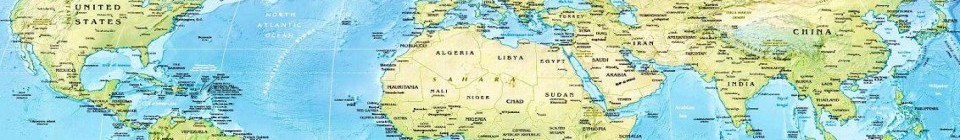

Here you can find online selected information about the geography, inhabitants, government, economy and history of Comoros. Included are selected statistics, an overview map and the detailed map of Comoros. But let's start with the flag of Comoros here:
Comoros - Overview:
What you should know about Comoros? Let's start with this: The archipelago of the Comoros in the Indian Ocean, composed of the islands of Mayotte, Anjouan, Moheli, and Grand Comore declared independence from France on 6 July 1975. France did not recognize the independence of Mayotte, which remains under French administration. Since independence, Comoros has endured political instability through realized and attempted coups. In 1997, the islands of Anjouan and Moheli declared independence from Comoros. In 1999, military chief Col. Azali Assoumani seized power of the entire government in a bloodless coup; he initiated the 2000 Fomboni Accords, a power-sharing agreement in which the federal presidency rotates among the three islands, and each island maintains its local government. Azali won the 2002 federal presidential election as president of the Union of the Comoros from Grand Comore Island, which held the first five-year term. Azali stepped down in 2006 and President Ahmed Abdallah Mohamed Sambi was elected to office as president from Anjouan. In 2007, Mohamed Bacar effected Anjouan's de-facto secession from the Union of the Comoros, refusing to step down when Comoros' other islands held legitimate elections in July. The African Union (AU) initially attempted to resolve the political crisis by applying sanctions and a naval blockade to Anjouan, but in March 2008 the AU and Comoran soldiers seized the island. The island's inhabitants generally welcomed the move. In May 2011, Ikililou Dhoinine won the presidency in peaceful elections widely deemed to be free and fair. In closely contested elections in 2016, former President Azali Assoumani won a second term, when the rotating presidency returned to Grande Comore.
Geography of Comoros
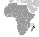 Where on the globe is Comoros? The location of this country is Southern Africa, group of islands at the northern mouth of the Mozambique Channel, about two-thirds of the way between northern Madagascar and northern Mozambique. Total area of Comoros is 2,235 sq km, of which 2,235 sq km is land. So this is quite a small country. How could we describe the terrain of the country? This way: volcanic islands, interiors vary from steep mountains to low hills. The lowest point of Comoros is Indian Ocean 0 m, the highest point Karthala 2,360 m. And the climate is tropical marine; rainy season (November to May).
Inhabitants of Comoros
Let's take a look how many people live in Comoros. The number is: 808,080 (July 2017 est.). So not so many people live here. Who lives here? Antalote, Cafre, Makoa, Oimatsaha, Sakalava. What are the languages in Comoros? Arabic (official), French (official), Shikomoro (official; a blend of Swahili and Arabic) (Comorian). And the religions: Sunni Muslim 98%, other (including Shia Muslim, Roman Catholic, Jehovah's Witness, Protestant) 2%. How old are the people in average? 19.9 years. We have to add that this number is the median - so one half of the people is older than this, one half is younger. And what is their life expectancy (at birth)? This: 64.6 years. Where the people live in Comoros? Here: the capital city of Maroni, located on the western side of the island of Grande Comore, is the country's largest city; however, of the three islands that comprise Comoros, it is Anjouan that is the most densely populated. The major urban areas of Comoros are: Moroni (capital) 56,000 (2014).
Government and Economy of Comoros
The capital of Comoros is Moroni and the government type federal presidential republic. Let's take a look at the administrative divisions - 3 islands and 4 municipalities; Anjouan (Ndzuwani), Domoni, Fomboni, Grande Comore (N'gazidja), Moheli (Mwali), Moroni, Moutsamoudou. Regarding the economy of Comoros, important industrial products are fishing, tourism, perfume distillation. Important agricultural products are vanilla, cloves, ylang-ylang (perfume essence), coconuts, bananas, cassava (manioc). The most important export commodities are vanilla, ylang-ylang (perfume essence), cloves and the most important export partners are France 25.6%, South Korea 15%, Germany 11.8%, India 10.4%, Singapore 4.4%, Russia 4.2%, Mauritius 4.1% (2016). The most important import commodities are rice and other foodstuffs, consumer goods, petroleum products, cement and construction materials, transport equipment and the most important import partners are UAE 29.5%, France 21.2%, China 11.3%, Pakistan 7.3%, Madagascar 6.2%, India 4.7% (2016). How rich is Comoros and how rich are people in this country? The most important number here is GDP per capita (PPP): $1,600 (2017 est.). This is a very low number. Let's add that this means Gross Domestic Product per person, which is recalculated with respect to the relative cost of local goods and services. And one more important number - population below poverty line: 44.8% (2004 est.).
