World Atlas: Equatorial Guinea. On this page you can see the map, country flag and many detailed information about the people, history and economy of Equatorial Guinea.

Here you can find online selected information about the geography, inhabitants, government, economy and history of Equatorial Guinea. Included are selected statistics, an overview map and the detailed map of Equatorial Guinea. But let's start with the flag of Equatorial Guinea here:
Equatorial Guinea - Overview:
What you should know about Equatorial Guinea? Let's start with this: Equatorial Guinea gained independence in 1968 after 190 years of Spanish rule; it is one of the smallest countries in Africa consisting of a mainland territory and five inhabited islands. The capital of Malabo is located on the island of Bioko, approximately 25 km from the Cameroonian coastline in the Gulf of Guinea. Between 1968 and 1979, autocratic President Francisco Macias Nguema virtually destroyed all of the country's political, economic, and social institutions before being deposed by his nephew Teodoro Obiang Nguema Mbasogo in a coup. President Obiang has ruled since October 1979 and was reelected in 2016. Although nominally a constitutional democracy since 1991, presidential and legislative elections since 1996 have generally been labeled as flawed. The president exerts almost total control over the political system and has placed legal and bureaucratic barriers that prevent political opposition. Equatorial Guinea has experienced rapid economic growth due to the discovery of large offshore oil reserves, and in the last decade has become Sub-Saharan Africa's third largest oil exporter. Despite the country's economic windfall from oil production, resulting in a massive increase in government revenue in recent years, the drop in global oil prices has placed significant strain on the state budget. Equatorial Guinea continues to seek to diversify its economy and to increase foreign investment despite limited improvements in the population's living standards. Equatorial Guinea is the host of major regional and international conferences and continues to seek a greater role in regional affairs.
Geography of Equatorial Guinea
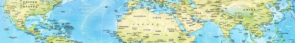
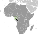 Where on the globe is Equatorial Guinea? The location of this country is Central Africa, bordering the Bight of Biafra, between Cameroon and Gabon. Total area of Equatorial Guinea is 28,051 sq km, of which 28,051 sq km is land. So this is not a large country. How could we describe the terrain of the country? This way: coastal plains rise to interior hills; islands are volcanic. The lowest point of Equatorial Guinea is Atlantic Ocean 0 m, the highest point Pico Basile 3,008 m. And the climate is tropical; always hot, humid.
Inhabitants of Equatorial Guinea
Let's take a look how many people live in Equatorial Guinea. The number is: 778,358 (July 2017 est.). So not so many people live here. Who lives here? Fang 85.7%, Bubi 6.5%, Mdowe 3.6%, Annobon 1.6%, Bujeba 1.1%, other 1.4% (1994 census). What are the languages in Equatorial Guinea? Spanish (official) 67.6%, other (includes French (official), Fang, Bubi) 32.4% (1994 census). And the religions: nominally Christian and predominantly Roman Catholic, pagan practices. How old are the people in average? 19.8 years. We have to add that this number is the median - so one half of the people is older than this, one half is younger. And what is their life expectancy (at birth)? This: 64.6 years. Where the people live in Equatorial Guinea? Here: only two large cities over 30,000 people (Bata on the mainland, and the capital Malabo on the island of Bioko); small communities are scattered throughout the mainland and the five inhabited islands. The major urban areas of Equatorial Guinea are: Malabo (capital) 145,000 (2014).
Government and Economy of Equatorial Guinea
The capital of Equatorial Guinea is Malabo; note - a new capital of Oyala is being built on the mainland near Djibloho; Malabo is on the island of Bioko and the government type presidential republic. Let's take a look at the administrative divisions - 7 provinces (provincias, singular - provincia); Annobon, Bioko Norte, Bioko Sur, Centro Sur, Kie-Ntem, Litoral, Wele-Nzas. Regarding the economy of Equatorial Guinea, important industrial products are petroleum, natural gas, sawmilling. Important agricultural products are coffee, cocoa, rice, yams, cassava (manioc, tapioca), bananas, palm oil nuts; livestock; timbe. The most important export commodities are petroleum products, timbe and the most important export partners are India 19.4%, China 13.5%, South Korea 13.2%, Spain 12.3%, Italy 5.1%, Netherlands 5.1%, US 4.1% (2016). The most important import commodities are petroleum sector equipment, other equipment, construction materials, vehicles and the most important import partners are US 23.3%, Spain 21.8%, China 12.8% (2016). How rich is Equatorial Guinea and how rich are people in this country? The most important number here is GDP per capita (PPP): $34,900 (2017 est.). This means the living standards are good here. Let's add that this means Gross Domestic Product per person, which is recalculated with respect to the relative cost of local goods and services. And one more important number - population below poverty line: 44% (2011 est.).
