World Atlas: Eritrea. On this page you can see the map, country flag and many detailed information about the people, history and economy of Eritrea.

Here you can find online selected information about the geography, inhabitants, government, economy and history of Eritrea. Included are selected statistics, an overview map and the detailed map of Eritrea. But let's start with the flag of Eritrea here:
Eritrea - Overview:
What you should know about Eritrea? Let's start with this: After independence from Italian colonial control in 1941 and 10 years of British administrative control, the UN established Eritrea as an autonomous region within the Ethiopian federation in 1952. Ethiopia's full annexation of Eritrea as a province 10 years later sparked a violent 30-year struggle for independence that ended in 1991 with Eritrean rebels defeating government forces. Eritreans overwhelmingly approved independence in a 1993 referendum. Isaias Afworki has been Eritrea's only president since independence; his rule, particularly since 2001, has been highly autocratic and repressive. His government has created a highly militarized society by pursuing an unpopular program of mandatory conscription into national service, sometimes of indefinite length. A two-and-a-half-year border war with Ethiopia that erupted in 1998 ended under UN auspices in December 2000. A UN peacekeeping operation was established that monitored a 25 km-wide Temporary Security Zone. The Eritrea-Ethiopia Boundary Commission (EEBC) created in April 2003 was tasked "to delimit and demarcate the colonial treaty border based on pertinent colonial treaties (1900, 1902, and 1908) and applicable international law." The EEBC on 30 November 2007 remotely demarcated the border, assigning the town of Badme to Eritrea, despite Ethiopia's maintaining forces there from the time of the 1998-2000 war. Eritrea insisted that the UN terminate its peacekeeping mission on 31 July 2008. Eritrea has accepted the EEBC's "virtual demarcation" decision and repeatedly called on Ethiopia to remove its troops. Ethiopia has not accepted the demarcation decision, and neither party has entered into meaningful dialogue to resolve the impasse. Eritrea is subject to several UN Security Council Resolutions (initially in 2009 and renewed annually) imposing an arms embargo and a travel ban and assets freeze on certain individuals, in view of evidence that it has supported armed opposition groups in the region.
Geography of Eritrea
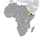 Where on the globe is Eritrea? The location of this country is Eastern Africa, bordering the Red Sea, between Djibouti and Sudan. Total area of Eritrea is 117,600 sq km, of which 101,000 sq km is land. So this is not a large country. How could we describe the terrain of the country? This way: dominated by extension of Ethiopian north-south trending highlands, descending on the east to a coastal desert plain, on the northwest to hilly terrain and on the southwest to flat-to-rolling plains. The lowest point of Eritrea is near Kulul within the Danakil Depression -75 m, the highest point Soira 3,018 m. And the climate is hot, dry desert strip along Red Sea coast; cooler and wetter in the central highlands (up to 61 cm of rainfall annually, heaviest June to September); semiarid in western hills and lowlands.
Inhabitants of Eritrea
Let's take a look how many people live in Eritrea. The number is: 5,918,919 (July 2017 est.). So this is not very populous country. Who lives here? nine recognized ethnic groups: Tigrinya 55%, Tigre 30%, Saho 4%, Kunama 2%, Rashaida 2%, Bilen 2%, other (Afar, Beni Amir, Nera) 5% (2010 est.). What are the languages in Eritrea? Tigrinya (official), Arabic (official), English (official), Tigre, Kunama, Afar, other Cushitic languages. And the religions: Muslim, Coptic Christian, Roman Catholic, Protestant. How old are the people in average? 19.7 years. We have to add that this number is the median - so one half of the people is older than this, one half is younger. And what is their life expectancy (at birth)? This: 65.2 years. Where the people live in Eritrea? Here: density is highest in the center of the country in and around the cities of Asmara (capital) and Keren; smaller settlements exist in the north and south. The major urban areas of Eritrea are: Asmara (capital) 804,000 (2015).
Government and Economy of Eritrea
The capital of Eritrea is Asmara (Asmera) and the government type presidential republic. Let's take a look at the administrative divisions - 6 regions (zobatat, singular - zoba); Anseba, Debub (South), Debubawi K'eyih Bahri (Southern Red Sea), Gash Barka, Ma'akel (Central), Semenawi Keyih Bahri (Northern Red Sea). Regarding the economy of Eritrea, important industrial products are food processing, beverages, clothing and textiles, light manufacturing, salt, cement. Important agricultural products are sorghum, lentils, vegetables, corn, cotton, tobacco, sisal; livestock, goats; fish. The most important export commodities are gold and other minerals, livestock, sorghum, textiles, food, small industry manufactures and the most important export partners are China 57.7%, India 21.9%, South Korea 4.9%, Serbia 4.2% (2016). The most important import commodities are machinery, petroleum products, food, manufactured goods and the most important import partners are China 18.1%, UAE 15.4%, Saudi Arabia 13.7%, Italy 6.5%, Turkey 5.9%, Brazil 5.3%, Belgium 4.1% (2016). How rich is Eritrea and how rich are people in this country? The most important number here is GDP per capita (PPP): $1,400 (2017 est.). This is a very low number. Let's add that this means Gross Domestic Product per person, which is recalculated with respect to the relative cost of local goods and services. And one more important number - population below poverty line: 50% (2004 est.).
