World Atlas: Saint Vincent and the Grenadines. On this page you can see the map, country flag and many detailed information about the people, history and economy of Saint Vincent and the Grenadines.

Here you can find online selected information about the geography, inhabitants, government, economy and history of Saint Vincent and the Grenadines. Included are selected statistics, an overview map and the detailed map of Saint Vincent and the Grenadines. But let's start with the flag of Saint Vincent and the Grenadines here:
Saint Vincent and the Grenadines - Overview:
What you should know about Saint Vincent and the Grenadines? Let's start with this: Resistance by native Caribs prevented colonization on Saint Vincent until 1719. Disputed between France and the UK for most of the 18th century, the island was ceded to the latter in 1783. Between 1960 and 1962, Saint Vincent and the Grenadines was a separate administrative unit of the Federation of the West Indies. Autonomy was granted in 1969 and independence in 1979.
Geography of Saint Vincent and the Grenadines
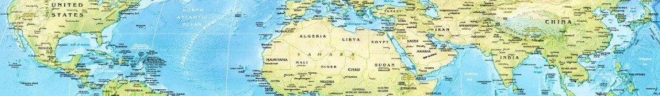
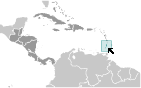 Where on the globe is Saint Vincent and the Grenadines? The location of this country is Caribbean, islands between the Caribbean Sea and North Atlantic Ocean, north of Trinidad and Tobago. Total area of Saint Vincent and the Grenadines is 389 sq km (Saint Vincent 344 sq km), of which 389 sq km is land. So this is quite a small country. How could we describe the terrain of the country? This way: volcanic, mountainous. The lowest point of Saint Vincent and the Grenadines is Caribbean Sea 0 m, the highest point La Soufriere 1,234 m. And the climate is tropical; little seasonal temperature variation; rainy season (May to November).
Inhabitants of Saint Vincent and the Grenadines
Let's take a look how many people live in Saint Vincent and the Grenadines. The number is: 102,089 (July 2017 est.). So not so many people live here. Who lives here? black 66%, mixed 19%, East Indian 6%, European 4%, Carib Amerindian 2%, other 3%. What are the languages in Saint Vincent and the Grenadines? English, French patois. And the religions: Protestant 75% (Anglican 47%, Methodist 28%), Roman Catholic 13%, other (includes Hindu, Seventh-Day Adventist, other Protestant) 12%. How old are the people in average? 33.6 years. We have to add that this number is the median - so one half of the people is older than this, one half is younger. And what is their life expectancy (at birth)? This: 75.5 years. Where the people live in Saint Vincent and the Grenadines? Here: most of the population is concentrated in and around the capital of Kingstown. The major urban areas of Saint Vincent and the Grenadines are: Kingstown (capital) 27,000 (2014).
Government and Economy of Saint Vincent and the Grenadines
The capital of Saint Vincent and the Grenadines is Kingstown and the government type parliamentary democracy (House of Assembly) under a constitutional monarchy; a Commonwealth realm. Let's take a look at the administrative divisions - 6 parishes; Charlotte, Grenadines, Saint Andrew, Saint David, Saint George, Saint Patrick. Regarding the economy of Saint Vincent and the Grenadines, important industrial products are tourism; food processing, cement, furniture, clothing, starch. Important agricultural products are bananas, coconuts, sweet potatoes, spices; small numbers of cattle, sheep, pigs, goats; fish. The most important export commodities are bananas, eddoes and dasheen (taro), arrowroot starch; tennis racquets and the most important export partners are Barbados 18.3%, St. Lucia 17.6%, Antigua and Barbuda 14.8%, Trinidad and Tobago 12.3%, Dominica 9.5%, St. Kitts and Nevis 7.3%, Grenada 5.9% (2016). The most important import commodities are foodstuffs, machinery and equipment, chemicals and fertilizers, minerals and fuels and the most important import partners are US 44%, Trinidad and Tobago 14.1%, UK 6.5%, France 4.8% (2016). How rich is Saint Vincent and the Grenadines and how rich are people in this country? The most important number here is GDP per capita (PPP): $11,600 (2017 est.). This is quite good. Let's add that this means Gross Domestic Product per person, which is recalculated with respect to the relative cost of local goods and services. And one more important number - population below poverty line: NA%.
