World Atlas: Sierra Leone. On this page you can see the map, country flag and many detailed information about the people, history and economy of Sierra Leone.
Here you can find online selected information about the geography, inhabitants, government, economy and history of Sierra Leone. Included are selected statistics, an overview map and the detailed map of Sierra Leone. But let's start with the flag of Sierra Leone here:
Sierra Leone - Overview:
What you should know about Sierra Leone? Let's start with this: The British set up a trading post near present-day Freetown in the 17th century. Originally the trade involved timber and ivory, but later it expanded into slaves. Following the American Revolution, a colony was established in 1787 and Sierra Leone became a destination for resettling black loyalists who had originally been resettled in Nova Scotia. After the abolition of the slave trade in 1807, British crews delivered thousands of Africans liberated from illegal slave ships to Sierra Leone, particularly Freetown. The colony gradually expanded inland during the course of the 19th century; independence was attained in 1961. Democracy is slowly being reestablished after the civil war (1991-2002) that resulted in tens of thousands of deaths and the displacement of more than 2 million people (about one third of the population). The military, which took over full responsibility for security following the departure of UN peacekeepers at the end of 2005, has developed as a guarantor of the country's stability; the armed forces remained on the sideline during the 2007 and 2012 national elections. In March 2014, the closure of the UN Integrated Peacebuilding Office in Sierra Leone marked the end of more than 15 years of peacekeeping and political operations in Sierra Leone. The government's stated priorities include furthering development - including recovering from the Ebola epidemic - creating jobs, and stamping out endemic corruption.
Geography of Sierra Leone
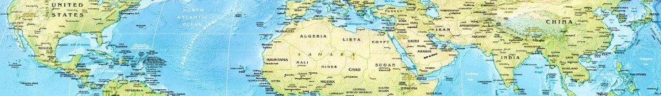
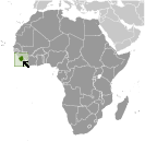 Where on the globe is Sierra Leone? The location of this country is Western Africa, bordering the North Atlantic Ocean, between Guinea and Liberia. Total area of Sierra Leone is 71,740 sq km, of which 71,620 sq km is land. So this is not a large country. How could we describe the terrain of the country? This way: coastal belt of mangrove swamps, wooded hill country, upland plateau, mountains in east. The lowest point of Sierra Leone is Atlantic Ocean 0 m, the highest point Loma Mansa (Bintimani) 1,948 m. And the climate is tropical; hot, humid; summer rainy season (May to December); winter dry season (December to April).
Inhabitants of Sierra Leone
Let's take a look how many people live in Sierra Leone. The number is: 6,163,195 (July 2017 est.). So this is not very populous country. Who lives here? Temne 35%, Mende 31%, Limba 8%, Kono 5%, Kriole 2% (descendants of freed Jamaican slaves who were settled in the Freetown area in the late-18th century; also known as Krio), Mandingo 2%, Loko 2%, other 15% (includes refugees from Liberia's recent civil war, and small numbers of Europeans, Lebanese, Pakistanis, and Indians) (2008 census). What are the languages in Sierra Leone? English (official, regular use limited to literate minority), Mende (principal vernacular in the south), Temne (principal vernacular in the north), Krio (English-based Creole, spoken by the descendants of freed Jamaican slaves who were settled in the Freetown area, a lingua franca and a first language for 10% of the population but understood by 95%). And the religions: Muslim 60%, indigenous beliefs 30%, Christian 10%. How old are the people in average? 19 years. We have to add that this number is the median - so one half of the people is older than this, one half is younger. And what is their life expectancy (at birth)? This: 58.6 years. Where the people live in Sierra Leone? Here: population clusters are found in the lower elevations of the south and west; the northern third of the country is less populated. The major urban areas of Sierra Leone are: Freetown (capital) 1.007 million (2015).
Government and Economy of Sierra Leone
The capital of Sierra Leone is Freetown and the government type presidential republic. Let's take a look at the administrative divisions - 3 provinces and 1 area; Eastern, Northern, Southern, Western. Regarding the economy of Sierra Leone, important industrial products are diamond mining; iron ore, rutile and bauxite mining; small-scale manufacturing (beverages, textiles, footwear). Important agricultural products are rice, coffee, cocoa, palm kernels, palm oil, peanuts, cashews; poultry, cattle, sheep, pigs; fish. The most important export commodities are iron ore, diamonds, rutile, cocoa, coffee, fish and the most important export partners are Cote dIvoire 31.7%, US 28.3%, Belgium 17.7%, China 6.6% (2016). The most important import commodities are foodstuffs, machinery and equipment, fuels and lubricants, chemicals and the most important import partners are China 12.5%, US 9.7%, India 7.8%, UAE 7.2%, Senegal 6.2%, Belgium 5.5%, Turkey 5.5%, UK 4.7% (2016). How rich is Sierra Leone and how rich are people in this country? The most important number here is GDP per capita (PPP): $1,800 (2017 est.). This is a very low number. Let's add that this means Gross Domestic Product per person, which is recalculated with respect to the relative cost of local goods and services. And one more important number - population below poverty line: 70.2% (2004 est.).
